Sunday, May 11, 2014

Joint New Zealand - German 3D survey reveals massive seabed gas hydrate and methane system

A joint New Zealand-German research team has discovered a huge network of frozen methane and methane gas in sediments and in the ocean near New Zealand’s east coast.

The 16-strong team is using state-of-the-art 3D and 2D seismic and echosounder technology to map both forms of methane within the ocean and beneath the seafloor.

The area off the North Island’s east coast is known to have very large active landslides, up to 15km long and 100m thick, and the team set out to discover what is causing them to move.

What they discovered was direct evidence of widespread gas in the sediment and ocean, and indications of large areas of methane hydrate, ice-like frozen methane, below the seafloor. The team has identified 99 gas flares in a 50 km² area, venting from the seabed in columns up to 250 m high. This is believed to be the densest concentration of seafloor gas vents known in New Zealand. 3D seismic data show that landslides and faults allow the gas built up in the sediment to be released into the ocean.

A 3D image of one section of New Zealand's
East Coast seafloor mapped in 3D, complete
with methane deposits and flares. [NIWA]
This discovery reveals a hydrate and gas field very different from others known in New Zealand.

“Previously all gas venting sites have been in deeper water and associated with large earthquake faults”, says NIWA marine geologist and voyage leader Dr Joshu Mountjoy.

“What we have found is high density methane flares in very shallow water, as well as gas building up beneath a large landslide and being released along the landslide margins”.

In a recently submitted scientific paper the team proposed that these landslides might be the seafloor equivalent of glaciers, but with frozen methane instead of water ice, or alternatively that pressurized gas is causing them to progressively move downslope. The results from this expedition indicate that both of these are possibilities and provide data to carefully test these hypotheses.

The expedition took the opportunity to deploy the German research institute GEOMAR’s high resolution 3D seismic equipment known as the P-Cable from NIWA’s research vessel Tangaroa

“This equipment is the best available for imaging fluid systems within the seafloor,” says co-leader Professor Sebastian Krastel of the University of Kiel. “The sediment, rocks and fluids we have mapped here are perfectly suited to this equipment, and the area mapped is one of the biggest ever mapped with the P-Cable seismic system.”

The work forms part of a larger project focused on understanding the dynamic interaction of gas hydrates and slow moving active landslides. Dubbed SCHLIP (Submarine Clathrate Hydrate Landslide Imaging Project), ongoing investigations in the project over the next decade will including drilling into the landslides themselves in 2016. This first part of the project, SCHLIP-3D, is a collaboration between NIWA, GNS Science and the University of Auckland from New Zealand, GEOMAR and the University of Kiel from Germany, Oregon State University from the USA, and the University of Malta.

“The initial findings are very important”, says Dr Mountjoy. “Methane is a very effective greenhouse gas and seabed methane release has the potential to dramatically alter the earth’s climate. As ocean temperatures change the methane hydrate system has the potential to become unstable.”

“In terms of natural hazards, the occurrence of very large slow landslides, rather than catastrophic ones, has major implications for the tsunami generating potential of landslides globally as slow landslides are unlikely to cause tsunami”.

“This type of slow moving submarine landslide is essentially unknown around the world, but it is very likely that they do occur widely and are an important process shaping continental margins”.

The team set off from Wellington on 14 April and finish the voyage there on 8 May. The work is funded from New Zealand by MBIE and Germany by DFG.


Source

Joint New Zealand - German 3D survey reveals massive seabed gas hydrate and methane system
News Release, May 12, 2014, NIWA (National Institute of Water and Atmospheric Research), New Zealand

Related

Pockmarks up to 11 km (6.8 mi) wide, off the coast of New Zealand's South Island, in:
Sea of Okhotsk


Tuesday, December 10, 2013

Noctilucent clouds: further confirmation of large methane releases

Back in September 2013, extremely high methane readings were recorded over the heights of Antarctica, as illustrated by the image below.


These high methane readings over Antarctica have not been discussed much among climate scientists, let alone in the media. Yet, large methane releases can contribute significantly to climate change, given methane's high potency as a greenhouse gas. Furthermore, the vast amounts of methane contained in the permafrost comes with the danger that, as global warming continues, such releases could increase in a non-linear way.

Noctilucent clouds could confirm that such emissions have indeed taken place from Antarctica. Methane will rise in the atmosphere, turning into water vapor as it rises up in the sky, and form ice crystals around meteor smoke at 83 kilometers altitude, showing up as noctilucent clouds.


 Noctilucent Clouds over the Southern Hemisphere from November 21, 2013, to December 17, 2013.
Click on each image to view enlarged versions.

It takes a while for methane to rise up to such altitudes, making it hard to pinpoint which methane releases are responsible for these noctilucent clouds. As methane rises, it tends to move closer to the equator, which is another reason to conclude that these noctilucent clouds are the result of large amounts of methane that have been released from the heights of Antarctica earlier in 2013.

As such high methane concentrations transform into water vapor and carbon dioxide, they may no longer register as methane on satellite measurements, yet they will continue to contribute to global warming. Therefore, large methane releases should be closely monitored, even if they do not appear to immediately translate into mean global methane level rises.

The question remains what caused such huge releases from the heights of Antarctica in the first place. The graph below may provide some of the answers. Look at the sharp temperature anomaly rise of 6 degrees Celsius over Antarctica in September 2013, preceded by a -3 anomaly. That's a difference of about 9 degrees Celsius. As temperature differences increase, there will be greater pressure changes, in line with compacting, expanding, tearing and other movements of the ice. Furthermore, more snowfall followed by more melting and vice versa will come with increased differences in weight. These two forces combined could be destabilizing the permafrost and the hydrates and free gas it contains.

Diagram showing area weighted Antarctic (70-90oS) monthly surface air temperature anomalies (HadCRUT4) since January 2000, in relation to the WMO normal period 1961-1990.  The thin blue line shows the monthly temperature anomaly, while the thicker red line shows the running 37 month (c.3 yr) average. Last month shown: September 2013. Last diagram update: 17 November 2013. From: http://www.climate4you.com/Polar%20temperatures.htm
The temperature differences more striking when looking at individual days in September 2013. The NOAA images below show a difference of well over 20°C over a few days in September 2013.


Temperature anomalies can be even more striking when looking at specific areas on specific days, such as on August 9th, 2013, as on the image below.


As said on the image, such anomalies (well over 20°C, in this case) can be masked when averaged out over longer periods and over a larger area, such as an area covering latitudes from 60S to 90S for all longitudes.

Recent research findings show that, as weight is lost due to melting, West Antarctica becomes more vulnerable to pressure from East Antarctica, which is pushing West Antarctic bedrock westward at rates up to about twelve millimeters—about half an inch—per year. This finding further confirms crustal motions that could destabilize methane hydrates contained in the permafrost.

The occurence of large temperature differences spells bad news, as they can trigger methane releases, the more so as wide and rapid temperature changes on Antarctica look set to become even more frequent and intense with further global warming.

Finally, the NASA video below gives more background details on noctilucent clouds.


References

- Is Global Warming breaking up the Integrity of the Permafrost?
http://methane-hydrates.blogspot.com/2013/05/is-global-warming-breaking-up-the-integrity-of-the-permafrost.html

- Noctilucent clouds indicate more methane in upper atmosphere
http://arctic-news.blogspot.com/2012/09/noctilucent-clouds-indicate-more-methane-in-upper-atmosphere.html

- Noctilucent Clouds Get an Early Start

- Aeronomy of Ice in the Mesosphere (AIM) satellite, exploring Polar Mesospheric Clouds (PMCs), also called noctilucent clouds


Wednesday, October 2, 2013

Earthquake M6.7 hits Sea of Okhotsk

An earthquake with a magnitude of 6.7 on the Richter scale hit the Sea of Okhotsk on October 1, 2013.

[click on image to enlarge ]

The submarine earthquake occurred at a depth of 359.3 miles (578.24 km). Earthquakes at such a depth can be felt at great distances from the epicenter.

The danger is that tremors will destabilize methane held in sediments underneath the Arctic Ocean. As above map shows, a fault line connects the Arctic Ocean with the Sea of Okhotsk through Siberia. As above map also shows, a lot of methane is already present over the Arctic on or close to this fault line.

The map below is added to better illustrate the location of the recent earthquake (large red dot at bottom center) and the fault lines.

[ click on image to enlarge ]

Related posts

- Earthquake hits Laptev Sea (2013)http://arctic-news.blogspot.com/2013/09/earthquake-hits-laptev-sea.html

- Methane release caused by earthquakes (2013)
http://arctic-news.blogspot.com/2013/09/methane-release-caused-by-earthquakes.html

- North Hole (2013)
http://arctic-news.blogspot.com/2013/09/north-hole.html

- Sea of Okhotsk (2013)
Methane-hydrates.blogspot.com/2013/06/sea-of-okhotsk.html

- Seismic activity, by Malcolm Light and Sam Carana (2011)
Arctic-news.blogspot.com/p/seismic-activity.html

- Thermal expansion of the Earth's crust necessitates geoengineering (2011)
Arctic-news.blogspot.com/p/thermal-expansion.html

Tuesday, July 9, 2013

Methanetracker


Above, a screenshot from a video, at youtube.com/watch?v=3l6PtWf4i9w, earlier posted as Cruising for methane with Sam Carana at the Arctic-news blog. The video was made with methanetracker.org where you can overlay IASI methane readings (over 1950 in yellow) on top of Google Earth.


Below are two videos made by Omar Cabrera who created methanetracker.org. The video directly below provides some good help how to operate methanetracker, while the video at the bottom gives an excellent overview of the methane situation over the past few months. 


Tuesday, June 4, 2013

Sea of Okhotsk

On May 29 and June 2, 2013, sudden peak levels of methane in the atmosphere were registered of respectively 2241 and 2238 ppb at an altitude of 33,647.8 ft (10,255.8 mi). Such very high levels are unusual, particularly at such a high altitude. What could have caused this?

Image by Sam Carana, adapted from screenshot from USGS.gov
A magnitude 8.3 earthquake hit the Sea of Okhotsk on May 24, 2013. Depth was over 378.4 mi (608.9 km).

Earthquakes at such a depth can be felt at great distances from the epicenter. Across Siberia, tremors were felt and buildings trembled. In Moscow, some 4500 miles (7242 km) away, local law enforcement officers evacuated 850 people from two apartment buildings after residents said the buildings were shaking, reported the NYTimes.

Screenshot from USGS.gov
The cluster of earthquakes and aftershocks (above image) is likely to have caused methane hydrates in the Sea of Okhotsk to become destabilized. Due to the long travel from the bottom of the sea to the sea surface, much of the methane may have been broken down by methane-eating bacteria without entering the atmosphere. Nonetheless, as indicated by the image below, large amounts of methane did reach the atmosphere in the vicinity of the location of these earthquakes.

[ created with: methanetracker.org - click on image to enlarge ]
The above image shows methane at ten altitudes close to sea level. Higher in the atmosphere, methane tends to center around the equator. The earthquakes in the Sea of Okhotsk are likely to have contributed to the above-mentioned peak readings. Due to the depth at which the earthquakes occurred, they caused tremors thousands of miles away and are therefore likely to have been caused additional destabilization of sediments elsewhere, especially along fault lines, with methane being released accordingly.

Particularly dangerous is the possibility that such a massive earthquake could trigger earthquakes further north, since a fault line connects the Sea of Okhotsk with the Laptev Sea, while a 5.4 magnitude earthquake (in blue on map above) did hit Siberia on this fault line earlier this year (on May 24, 2013).

Global methane levels have risen over the past few years and, without action, levels of methane in the atmosphere can be expected to continue to rise. There are some well-known sources of methane that are causing this increase, such as the growing number of vehicles around the world that are powered by fossil fuel and an increase in the number of coal-fired power plants in Asia. Lesser-known causes are emissions due to wildfires, fracking and a growing appetite for meat in developing countries. Some of the least-reported causes include increased methane levels in the atmosphere due to:
  • Seabed destabilization - Global warming causes extreme weather events that warm up the seabed. In addition, earthquakes contribute to destabilization of sediments containing huge amounts of methane in the form of free gas and hydrates.
  • Melting permafrost - As the permafrost melts, it will be less capable to act as a cap that prevents methane originating from hydrates to enter the atmosphere, as discussed in more detail  in a recent post.
  • Aquifers - Water in aquifers can contain high levels of dissolved methane. A hotter planet will see crop yields fall while increasing the need for irrigation, as has been concluded by studies such as this Rice University and the University of California at Davis study. Pumping up more water will come with more methane escaping from aquifers.
  • Less oxygen in water - As levels of free oxygen in water decrease, there is less opportunity for methane-eating bacteria to break down methane in the water. This is particularly important in case of large abrupt releases of methane from hydrates. A two-part study by Berkeley Lab and Los Alamos National Laboratory shows that, as global temperature increases and oceans warm, methane releases from clathrates would over time cause depletion of oxygen, nutrients, and trace metals needed by methane-eating microbes, resulting in ever more methane escaping into the air without being broken down in the water, as also described in an earlier post.


    Accordingly, as above image shows, high levels of methane are projected for the Sea of Okhotsk by this study. 
To get a better idea of the scale of the threat, a study published in 2010 points at pockmarks up to 11 km (6.8 mi) wide off the coast of New Zealand, in an area prone to earthquakes, indicating that large emissions from methane hydrates did occur in the past. The image below is from the April 2013 Press Release 


Related

- Warming Gulf Stream causes methane release
http://arctic-news.blogspot.com/2012/10/warming-gulfstream-causes-methane-release.html

- Is Global Warming breaking up the Integrity of the Permafrost?
http://methane-hydrates.blogspot.com/2013/05/is-global-warming-breaking-up-the-integrity-of-the-permafrost.html

- Large areas of open ocean starved of oxygen

High daily peak methane readings continue over Antarctica


Above chart shows that, over the past two months, high daily peak methane readings have been recorded over Antarctica. For comparison, the image below, by Dr. Leonid Yurganov, shows the methane levels averaged for April 2013, as registered by the NASA AIRS satellite. This may also help locate the source of these high levels of methane.
Related posts:

- Is Global Warming breaking up the Integrity of the Permafrost?
http://methane-hydrates.blogspot.com/2013/05/is-global-warming-breaking-up-the-integrity-of-the-permafrost.html

Wednesday, May 22, 2013

Is Global Warming breaking up the Integrity of the Permafrost?

Permafrost was long thought to act as a cap preventing methane from hydrates to enter the atmosphere. For many years, University of Alaska Fairbanks scientists Natalia Shakhova and Igor Semiletov studied methane emissions in the Arctic Ocean. In a 2010 press release, Shakhova said: "The amount of methane currently coming out of the East Siberian Arctic Shelf is comparable to the amount coming out of the entire world's oceans. Subsea permafrost is losing its ability to be an impermeable cap."

Is something similar happening to the permafrost in Antarctica and on the Himilayan Plateau? As the image below shows (mid-May 2013 levels, image added later by Sam Carana), very high levels of methane can be present over Antarctica around this time of year.


The chart below shows very high methane levels over Antarctica in April and May 2013. High levels of methane over Antarctica were recorded before in 2013, as described in an earlier post at the methane-hydrates blog.


While above chart gives the peak readings at an altitude of 19,820 ft (or 6,041 m), the highest methane readings over Antarctica were not always recorded at that altitude. On April 29 and 30, 2013, when the above chart shows relatively low peak readings, readings of 2225 ppb were recorded at a lower altitude (14,385 ft or 4,384 m) over Antarctica. Similarly, the image below shows a reading of 2247 ppb on April 4, 2013, at that same lower altitude, higher than the peak reading for that day on above chart.


Are these high methane levels indications that global warming is breaking up the integrity of the permafrost in Antarctica as well?

The Himalayan Plateau, also known as the Qinghai-Tibetan Plateau, or the world’s “third pole”, is located in central Asia and also contains huge quantities of permafrost. Methane hydrates were discovered on the Qinghai-Tibet Plateau in September 2009 in quantities estimated "to equal at least 35 billion tonnes of oil", according to a 2010 Xinhuanet report.

The above chart with Antarctic daily peak methane readings gives an estimate for the highest methane reading over Antarctica on April 26, 2013. This because Antarctica didn’t appear to have the highest reading on that day, when methane readings were recorded of 2405 ppb at 469 mb pressure and of 2475 ppb at 367 mb pressure. The methane that caused these readings appears to originate from the Himalayan Plateau, as illustrated by the image below.


What could have caused such extremely high methane emissions?

Could the methane have been released from wetlands? It was very hot around that time in South Asia, as illustrated by the image below showing temperatures in degrees Celsius for April 28, 2013. But the emissions appear to originate from an area with little vegetation, which also appears to rule out burning of biomass waste from rice productions as a cause.


Another explanation for such high methane readings is that they were caused by earthquakes. The image below shows a string of earthquakes that hit China, including a magnitude 6.6 quake on April 20, 2013, and a magnitude 5.3 quake on April 24, 2013.


It could be that the earthquakes lead to large methane releases from ruptured natural gas pipes and tanks. On the other hand, the methane releases appear to occur over a large area well next to the epicenter of the earthquakes, as shown on the animation below.


Also, methane releases associated with such a natural disaster would have been a one-off event. High methane levels did occur before over the Himalayan Plateau, as illustrated by the image below showing readings for several days in 2013 at the same altitude, including a reading of 2235 ppb on February 1, 2013.


Such recurring high readings could indicate that methane is bubbling up through the permafrost at the Himalayan Plateau. Shockwaves caused by the earthquakes could have accelerated the movement of free gas through the top layers of permafrost and they could also have caused destabilization of one or more methane hydrates, resulting in large abrupt release of methane into the atmosphere on April 26.

Loss of the integrity of the permafrost is particularly threatening in the Arctic, where the sea ice looks set to disappear within years, resulting in huge albedo changes in summer. Decrease of surface reflectivity results in increases in absorption of energy from sunlight and decreases in shortwave radiation in the atmosphere. The latter results in lower photo-dissociation rates of tropospheric gases. Photo-dissociation of the ozone molecule is the major process that leads to the production of OH (hydroxyl radical), the main oxidizing (i.e., cleansing) gas species in the troposphere. A 2009 NASA study projects this to lead to a decrease in OH concentrations and a weakening of the oxidizing capacity of the Arctic troposphere, further increasing the vulnerability of the Arctic to warming in case of additional methane releases.

Levels of greenhouse gases such as carbon dioxide and methane are already very high in the Arctic atmosphere, while large quantities of black carbon get deposited on snow and ice, further contributing to the albedo changes. This threatens to result in rapid summer warming of many parts of the Arctic Ocean with very shallow waters. Additionally, rivers can bring increasingly warm water into those shallow seas in summer, adding to the threat that heat will penetrate the seabed that contains huge quantities of methane.

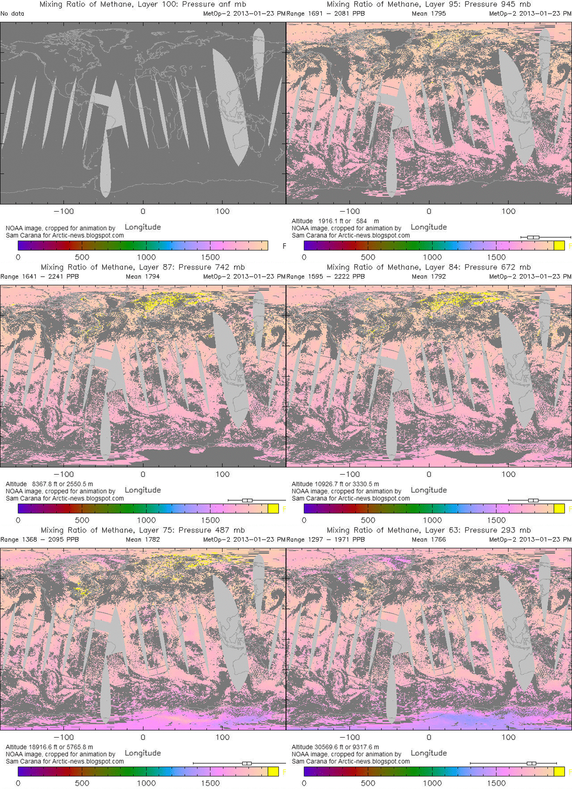
Methane at up to 2241 ppb on January 23, 2013 - this is a 2.42 MB animation that may take some time to fully load

Above image, earlier included in a post at the Arctic-news blog, shows methane concentrations on January 23, 2013, when a reading of 2241 ppb was recorded in the Arctic. 

Analysis of sediment cores collected in 2009 from under ice-covered Lake El'gygytgyn in the northeast Russian Arctic suggest that, last time the level of carbon dioxide in the atmosphere was about as high as it is today (roughly 3.5 to 2 million years ago), regional precipitation was three times higher and summer temperatures were about 15 to 16 degrees Celsius (59 to 61 degrees Fahrenheit), or about 8 degrees Celsius (14.4 degrees Fahrenheit) warmer than today.

As temperatures rose back in history, it is likely that a lot of methane will have vented from hydrates in the Arctic, yet without causing runaway warming. Why not? The rise in temperature then is likely to have taken place slowly over many years. While on occasion this may have caused large abrupt releases of methane, the additional methane from such releases could each time be broken down within decades, also because global methane levels in the atmosphere were much lower than today.

In conclusion, the situation today is much more threatening, particularly in the East Siberian Arctic Shelf (ESAS), as further described in the earlier post methane hydrates.